SEJournal Online is the digital news magazine of the Society of Environmental Journalists. Learn more about SEJournal Online, including submission, subscription and advertising information.
 |
 |
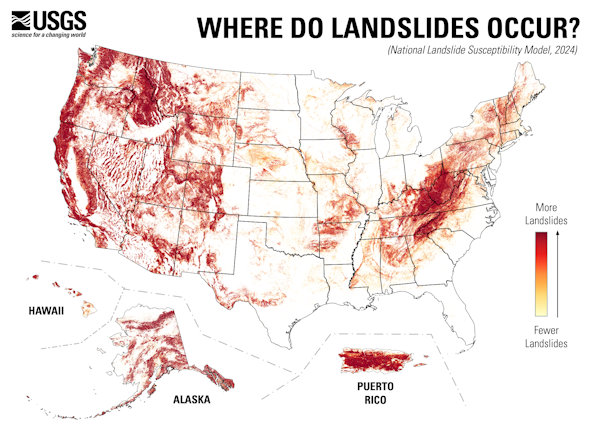
| The data that goes into the USGS landslide susceptibility map, shown above, includes not just expert assessments of current risk, but historical landslides and ancient landslides reconstructed from geology. Image: USGS. |
Reporter’s Toolbox: New-Look Landslide Risk Database Captures Potential Human Costs
By Joseph A. Davis
You wouldn't think that 44% of the land in the United States is at risk from landslides. But perhaps that’s the problem.
It was only a decade ago that a landslide in Oso, Washington, killed 43 people. Today, concern over landslides is only mounting (Hurricane Helene and its aftermath caused 1,400 landslides in North Carolina alone, per the Associated Press).
Increasing wildfires strip landscapes of stabilizing vegetation and bring landslide risk to places where people never thought of them. Some landslides follow earthquakes and more extreme rain events are another trigger.
Sometimes it’s too much building. These days, with climate heating in Alaska, for instance, it may involve melting of glaciers or permafrost.
A fresh presentation makes it easy
for environmental journalists to
work up stories about landslide risk
— from local to national in scope.
The U.S. Geological Survey has the best data on landslides (as you would expect). But a fresh presentation makes it easy for environmental journalists to work up stories about landslide risk — from local to national in scope.
It also makes easier the more ambitious data journalism projects that can show how to avoid the human cost of landslides.
Get an overview of the USGS landslide program, with this very cool map. You can access the data itself; literally type in your address and get your local picture.
Where the data comes from
This data is about as reliable as you can get.
The USGS, you may remember, has been mapping every bit of the U.S. since 1879. It makes those topographic maps you go hiking with. It is a science-only agency, without political or regulatory distractions.
But the data that goes into the USGS landslide susceptibility gauge is of several kinds. It includes actual historical landslides and ancient landslides reconstructed from geology, as well as expert assessments of current risk.
USGS geologists have done their best to put this data into a common and comparable format — with an emphasis on the level of risk.
How to use the data smartly
It’s all about overlays. Or rather, it’s all about how landslides can affect people.
Because the data is presented in map form, you can overlay it with available information about human activities and structures. When you do a query on the interactive map interface, you get a map in ArcGIS format, which allows you to add your own layers.
A menu of overlays allows you to see how
landslide risk relates to local zoning
codes. Or residential development.
Or especially vulnerable locations.
The USGS thoughtfully provides a menu of overlays you might want to use.
This allows you to see, for example, how landslide risk relates to local zoning codes. Or residential development, where the risk of casualties may be higher. Or especially vulnerable locations like schools and nursing homes.
Or roads and bridges that could isolate communities if they are destroyed. Or other critical infrastructure, whether power plants, chemical plants, electric transmission lines, rail lines, etc.
As always with data stories, don’t forget the shoe-leather reporting. Groundtruth everything. Talk to geology experts at local universities. Go to the site, talk to people and use your eyes.
Joseph A. Davis is a freelance writer/editor in Washington, D.C. who has been writing about the environment since 1976. He writes SEJournal Online's TipSheet, Reporter's Toolbox and Issue Backgrounder, and curates SEJ's weekday news headlines service EJToday and @EJTodayNews. Davis also directs SEJ's Freedom of Information Project and writes the WatchDog opinion column.
* From the weekly news magazine SEJournal Online, Vol. 9, No. 39. Content from each new issue of SEJournal Online is available to the public via the SEJournal Online main page. Subscribe to the e-newsletter here. And see past issues of the SEJournal archived here.


 Advertisement


